A Brief Overview of the Communities of the Grapevine
Father Jose Zalvidea is credited for naming the canyon Canada de las Uvas in 1806, though it no doubt had always been referred to as the canyon of the grapes for the Cimarron grapes that have long grown there.

Grapevine Canyon has the unusual history of holding five villages within its arms. The first recorded settlement was that of the village of “Mat’apxwelxwel” thought to be occupied by a variety of Native people as it was on the edge of the lands of a number of tribes. Much evidence of these people was left by the scores of bedrock milling mortars once located and recorded along the fast flowing, year-around stream there.

When very few Native people yet remained, a second community developed just below or to the north. It is thought that the village of “Los Pueblo de las Uvas” was established during and after the building of Fort Tejon with many of the men having been used as laborers in the building of the fort. Writer, Mary Austin, visited the village often when she lived at the nearby stage and wagon stop of Rose Station. She told of the gardens, vine covered patios and the growl of an arasta at the nearby “La Golondrina” mine. Miss Austin wrote that Father Shannon would make his rounds to the village to marry, christen and bury villagers in a cemetery full of pine headboards covered with paper roses. Mass was held in the school where an altar was set up.

The third community of the Grapevine was established for the growing number of travelers as a needed rest stop at the base of the twisting Grapevine Grade. California Highway #4, more commonly called the Ridge Route as it passed through the mountains between Los Angeles and Bakersfield, had just been constructed. The road stop located just south or uphill from the Indian and Mexican villages. Between the workers needed for the oil pumping stations then in the canyon and the roadside businesses, the population grew. The post office was established in July of 1923, with the founder of the community, Leonard McLarty, as the postmaster. It was not uncommon for travelers to ask for a night’s shelter at the homes there until two auto courts were built.

In the mid-1930’s the Ridge Route was expanded to three lanes and in the 1940’s to four lanes. The three and four lane highway, California #99 was also known as the Golden State Highway. It was located on the hillside on the west side of the of the canyon and the old Ridge Route Road was then closed. The commercial business of Grapevine #3 closed and many relocated high on the hillside by the new highway. A Union 76 service station, garage, a twelve cottage “motor hotel”, post office, about seven homes and a fine restaurant with a bar that overlooked the San Joaquin Valley became the nucleus of the new community.
The new location proved to be a dangerous one as a number of vehicles with failed brakes ran into the buildings there. One of the village’s most memorable accidents was in September of 1949 when the brakes failed on a twenty-ton truck loaded with engine blocks. It plowed through six parked cars, slammed into the gasoline stations and swept six more cars 150 feet down into the canyon behind the station. Two people were killed and many more injured. Half the town went up in flames from the resulting fire, though it was quickly rebuilt. In the 1950’s a truck load of oranges ran through the gas pumps at the Union 76 station and also took out the post office.

The greatest natural disaster to the area was the July 21th, 1952″Tehachapi Earthquake”. At a magnitude of 7.7 it was the largest earthquake in Southern California since the 1857 earthquake that had centered at the top of the canyon in Tejon Pass. The communities of the Grapevine were badly damaged – especially the older adobe buildings still being used in the area. The pump island at the gas station dropped a foot below the level of the building but they quickly built a ramp to get the vehicles being serviced in and out of the garage. Several rock slides occurred on the Grapevine grade and the paving was twisted and broken but the highway was not closed.
In 1960 signs at the north and south entrances to Grapevine #4 said the town had a population of 100, though residents admitted that it was really 22 people and 78 stray cats and dogs lost by travelers stopping there. This community was closed in the early 1960’s when the eight lane highway was being built. The present commercial area, Grapevine #5, was established as a result of lease arrangements with the owners of the land, Tejon Ranch Company.
Grapevine Community 2007
The Grapevine Community as it is today in 2007
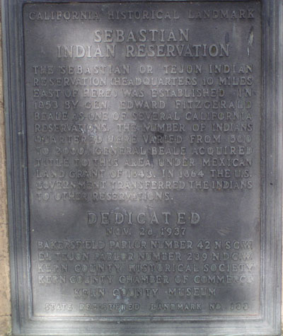
Two historical plaques are located on the western side of community across the street from Don Perico’s restaurant.
One is to commemorate Rose Station and the other is to commemorate Sebastian Indian Reservation.
 |
 |
Additional information may be found in “A View from the Ridge Route” series