A Brief Overview of the History of Frazier Park
The first settlement in the area of the future Frazier Park was a summer village of the Chumash Indian people located in a magnificent oak grove at the base of the mountain they called “Toshololo”. The village was called “wo’oht apaovea” which meant the grasshopper’s watering hole or “Grasshopper Spring”.
In the mid-1850’s the area became known as “Campo del Soldado” or Soldier’s Field when the men of Fort Tejon established an early lumber mill among the oaks to provide lumber for the building of the new military post.
When the mill was moved the next recorded non-Indian resident was a relative of the owners of the property Fort Tejon was located on, Samuel Young, and possibly his brother James. It is thought they located to the east of Soldier’s Field at the base of a canyon that still bears the name of Sam Young.
John Cuddy, who had established a ranch just west of Lake of the Woods, then acquired the future area of Frazier Park under a Federal Act allowing the reclamation of such “swamp and overflow lands”. The entire canyon then became known as Cuddy Canyon with the mountain to the south known as Cuddy Peak. When the youngest of the Cuddy children Marcus came of age, he took over the Campo del Soldado claim and built his home and barn in the area of today’s park.

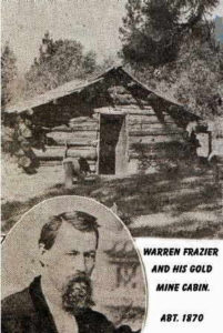
The next to influence the future of the area were the Frazier brothers, William, Warren and Edgar, who in 1870 established a very profitable gold mine on the south slope of the mountain that would soon bare their name. According to records located thus far, William was the only brother to own property in the present area of Frazier Park.
By the early 1900’s the oaks and pines around Mark Cuddy’s ranch were a popular mountain camping and vacation spot for the new automobile enthusiasts looking for places to drive to away from the city. Many of these campers were known to bed down on the hay in the Cuddy barn and to join in the recreational pack trains that were running over Frazier Mountain to Fillmore.

(Vina Young Collection)
When Marcus Cuddy and his wife, Dessie, divorced she acquired the property and the 800 acres ended up in the hands of developers from Glendale. The plans were to turn the area into an “up to date” country club with club house, riding stables, golf course, seven lakes and rustic mountain cabin sites. Under the name of Frazier Mountain Park & Fisheries Company (later changed to Frazier Mountain Park rod & Reel Club) some of this did come about though there were only five ponds completed and the golf course never happened. A popular 45′ X 90′ swimming pool was later added with water as cool as the mountain springs that fed it.


(No longer there)
During the filling of the lakes the owner of the famous hotel at Lebec filed a lawsuit against the developers in 1927 for diverting the flow of water in Cuddy Creek. The developers won the case but it did stop them from going on to fill lakes six and seven.
The 1925 development was done primarily for the enjoyment of the citizens of Glendale with the main street (now Mt. Pinos Way) known as Brand Blvd., the same name as the main street in the city of Glendale. The development was soon opened to all, with free lots given away at nearby county fairs to further encourage growth. Bus loads of folks were brought up for the day to see the area and enjoy a free picnic in the park.
Early Frazier Park – gas station

Mt. Pinos Way and Los Padres Drive.
Markets, lumber yards, lunch rooms and taverns soon followed as did the post office and schools, all of which have been in numerous locations throughout the community, though the Mountain Inn and Tavern have remained consistent in their purpose and location. Electricity arrived in 1927 but telephone service was not common until the 1950’s.

[Photo – Grace Bradley Toenjes]

[Photo courtesy of Grace Bradley Toenjes]
By 1930 the population of Frazier Mountain Park had grown to about 150 people but the Depression of the early 1930’s soon took it’s toll. The price of lots dropped from the $100 to $200 range they had begun at, to $3 to $10 each and bootlegging, gambling and prostitution were found in the small remote mountain community.

When the developers had to borrow against the subdivision areas set aside for the park and ponds, and could no longer make their payments, those areas were sold. The residents of the community were outraged. They formed the Frazier Park Protective Association and some years later won a judgment in which the property was given back to the community under the care of the Kern County Parks System as it still is today.
The Protective Association then became the Frazier Park Community Association which saw to the concerns of the community for some years after that.
Today, Frazier Park is a thriving community of some 4000 permanent and part-time resident who continue to enjoy the same fresh air, beautiful mountains and seclusion that the original settlers found.
Additional information may be found in “A View from the Ridge Route” series
